
About
Rashid Majidov is a professional Cartographer and Geodesy Engineer with over 12 years of experience. He combines both scientific knowledge and practical skills, giving special attention to accuracy and quality in every project he works on. His professionalism goes beyond technical abilities, ensuring proper planning, management, and effective execution of projects.
Throughout his career, Rashid has participated in a number of complex local and international geological and infrastructure projects. These experiences have enabled him to work effectively in diverse environments and conditions, achieving high-precision results both independently and within a team. For Rashid, cartography is not just about drawing maps; it is about presenting data visually in a way that is easily understandable for everyone. His approach simplifies complex spatial information into clear and accessible formats.
His work covers a wide range of fields: geological exploration, urban planning, environmental monitoring, natural resource management, and data analysis using various GIS (Geographic Information Systems) software. In every project, Rashid prioritizes accuracy, reliability, and efficiency. He is also engaged in pedagogical activities, sharing his expertise in geodesy and cartography with students for over ten years, contributing to the development of the next generation of specialists.
Rashid continuously follows new technologies and innovations in his field, applying modern methodologies in his work to improve project quality and further his professional development. His energy, enthusiasm, and knowledge make him one of the most reliable and promising experts in geodesy and cartography.
Combining both practical and scientific activities, Rashid is a key member of our team, playing a significant role in the successful execution of projects, scientific research, and the implementation of innovative solutions. His goal is to participate in prestigious projects both nationally and internationally, contributing continuously to the advancement of geodesy and cartography.
He is also the author of the book "GİS hamı üçün".
Personal Details
Education
Geodesy and Cartography Engineer
Years of study: 2008 - 2012
Work Experience
"Alphabet Baku" Training Center
Pedagogical activity: Specialized courses in Geodesy, Cartography, Remote Sensing, and Geographic Information Systems (GIS).
Taught software: ArcGIS Pro & ArcMap, AutoCAD Civil 3D, Global Mapper, ENVI, Erdas Imagine, QGIS.
During this period, Rashid Majidov imparted deep theoretical and practical knowledge to hundreds of students in these fields, helping them to make a successful start to their professional careers.
GeoCompany LLC
Chief Specialist in Cartography
Certificates and Achievements
Rashid Majidov has continuously improved his professional knowledge and obtained numerous local and international certificates. These certificates are a testament to his proficiency in modern technologies and methodologies.
Using ArcMap in ArcGİS Desktop 10
Issuing body: Esri
Date of issue: 23.06.2012
Field GİS: Collecting and Editing Data Using ArcPad 10
Issuing body: Esri
Date of issue: 22.07.2012
QGIS Professional User
Issuing body: QGIS.org
Date of issue: 10.11.2012
Using Python in ArcGİS Desktop 10
Issuing body: Esri
Date of issue: 15.08.2012
Getting Started with GİS (for ArcGİS 10.3)
Issuing body: Esri
Date of issue: 12.06.2013
Remote Sensing with Python
Issuing body: Coursera
Date of issue: 19.01.2014
Sharing GİS Content Using an ArcGİS Online Subscription
Issuing body: Esri
Date of issue: 30.11.2014
GIS for Urban Planning
Issuing body: Esri
Date of issue: 18.10.2015
Authoring Web Maps Using ArcGİS Online
Esri
Date of issue: 25.04.2016
Open Source GIS Applications
Issuing body: GeoAcademy
Date of issue: 10.08.2016
Hydrogeological Mapping
Issuing body: Esri
Date of issue: 14.11.2017
Environmental GIS Analysis
Issuing body: WWF
Date of issue: 05.03.2018
Python for Geospatial Analysis
Issuing body: Esri
Date of issue: 12.06.2018
Cloud GIS with ArcGIS Online
Issuing body: Esri
Date of issue: 28.11.2020
Geological Mapping with Field Tools
Issuing body: Esri
Date of issue: 05.02.2021
Advanced Database Design for GIS
Issuing body: Esri
Date of issue: 18.05.2022
Skills
Computer skills:
- ArcGIS (Esri)
- QGIS (Quantum GIS)
- MapInfo Professional
- ERDAS IMAGINE
- GRASS GIS
- ENVI
- AutoCAD Map 3D
- Global Mapper
- Surfer (Golden Software)
- GeoMedia (Hexagon Geospatial)
- Manifold System GIS
- ILWIS (Integrated Land and Water Information System)
- gvSIG
- MapWindow GIS
- OpenJUMP GIS
- SAGA GIS (System for Automated Geoscientific Analyses)
- Whitebox GAT
- uDig (User-friendly Desktop Internet GIS)
- GeoServer
- PostGIS
- Google Earth Pro
- Bentley Map
- Carto (previous CartoDB)
- Maptitude
- FME (Feature Manipulation Engine)
- Smallworld GIS (GE Digital)
- TatukGIS
- Geomatica (PCI Geomatics)
- SuperMap GIS
- Maptitude GIS
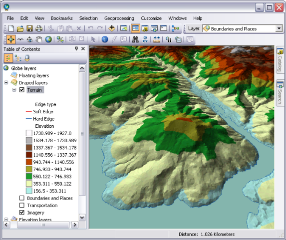
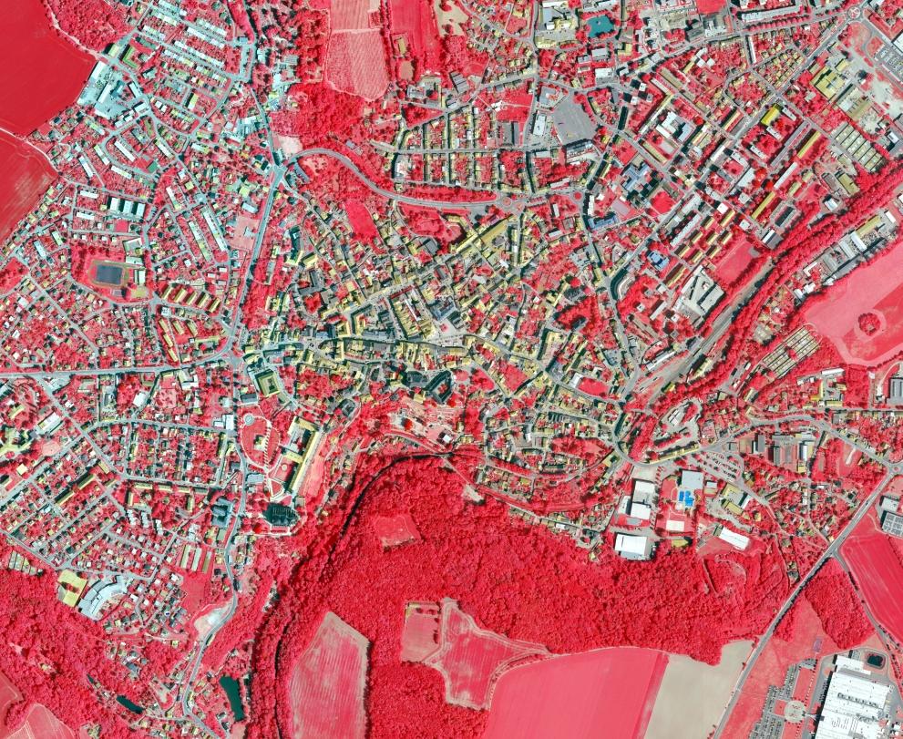
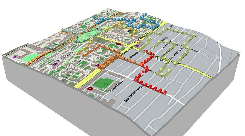
Map Samples
Visual examples from some of the maps and research projects he has prepared.
 AZ
AZ EN
EN RU
RU